| Product(s): |
WaterGEMS, WaterCAD, SewerGEMS, SewerCAD |
| Version(s): |
08.11.XX.XX, 10.XX.XX.XX |
| Area: |
Other |
Problem
How can a hydraulic model be exported to Google Earth? (.kmz file)
Solution - MicroStation
Open the WaterGEMS/CAD file in Microstation.
1) Go to Tools > Geographic > Select Coordinate System. If the file has a coordinate system, then skip this step.
2) From the File menu, go to Export > Google Earth. Enter a name for the .kmz file.
See the help topic "Google Earth Export from the MicroStation Platform" for more details.
Solution - ArcGIS
In WaterGEMS, SewerGEMS or HAMMER for ArcMap, you can use ArcToolbox to export the hydraulic model layers to KML. See the help topic "Google Export From ArcGIS" for details.
Solution - QGIS
If you do not have access to MicroStation or ArcGIS, Google Earth export can be accomplished with the free QGIS application.
1. With the model open, open a FlexTable with elements of interest (e.g., pipes) and configure the desired columns, You may want to create a new project-level flextable with a smaller number of fields added.
2. Export the FlexTable to ESRI SHP file. See: Converting your model elements to shapefile
3. Create a new project in QGIS
4. In QGIS, go to Layer > Add a layer > Vector layer
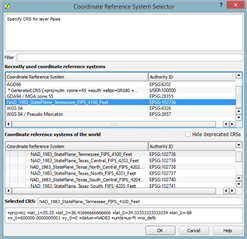
5. Add the shapefile making sure to choose the correct Coordinate Reference System
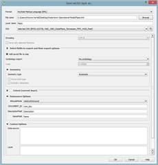
6. Right click on Layer > Save As > Keyhold Markup Language (KML)
7. Open the KML file in Google Earth
See Also
Adding Google Earth or Bing Maps aerial or road maps as a background layer