Tool to create a grid index list for locations on maps, e.g. for street names. A text file (CSV) is produced containing the locations to be included in the DGN as an index table. The names are sorted alphabetically and made unique.
This is a possible replacement for the MapIndex tool that was available in CadScript and in the Map Finishing tools of OpenCities Map v8i.
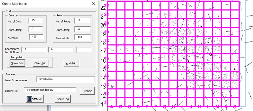
Workflow
Below the steps to create a name index.
- Open a model with the (street)names.
- Optionally rotate the sheet border. Finally, the sheet border must be horizontal.
- Load the VBA MapIndex.mvba and open the dialog Create Map Index.
- Fill-in the values in the dialog Create Map Index.
- Enter the details for the rows and columns.
- Enter the coordinates of the left bottom corner. The grid is calculated from left to right and from bottom to top in horizontal and vertical direction.
Note: If the row sequence is not from bottom to top or the column sequence is not from left to right, or the grid is not horizonal, rotate the content of the model (e.g., using a fence tool). Finally, the left bottom corner of the grid is the start point for calculating the index.
- Optionally show the grid and add the grid.
- Show Grid, the grid is displayed temporally in the hilite color and active textsettings (using snappable transient elements).
- Clear Grid, the grid is removed from the display.
- Add Grid, the grid is added permanently into the DGN file. The grid is presented with the active symbology and active text settings.
- Enter the level name of the texts.
- Enter the name of the Export file (CSV) that will be created.
Use Browse, to select the export file.
- Select the Create button.
In the created index file (CSV ) , a X-Y Grid Reference (street directory style) is created.
E.g. street names are sorted alphabetically and made unique.
You can open this text file in a text editor for reference, or you can import the text using File > Import > Text in MicroStation and click in the file where you want the text to be placed.