
| |
|
|
|
| |
Applies To |
|
|
| |
|
|
|
| |
Product(s): |
Bentley WaterGEMS, Bentley SewerGEMS, Bentley CivilStorm, Bentley StormCAD, Bentley PondPack, Bentley SewerCAD, Bentley HAMMER, Bentley WaterCAD |
|
| |
Version(s): |
08.11.XX.XX |
|
| |
Environment: |
N/A |
|
| |
Area: |
Layout and Data Input |
|
| |
Subarea: |
|
|
| |
Original Author: |
Mark Pachlhofer, Bentley Technical Support Group |
|
| |
|
|
|
Problem Description
How can I export my GIS-ID's to a shapefile?
Steps to Accomplish
1) Create an excel spread sheet with a column titled "Label" and another column titled "GIS-ID"
2) With your model file open go to Tools > Modelbuilder and create a new Modelbuilder run by clicking the icon that looks like a white sheet of paper
3) For the datasource type on step one of Modelbuilder select "Excel 2013/2010/2007 (12.0)" and choose the spread sheet location you created in step 1 above
4) Click next until you get to step 5 of modlebuilder, which is the field mapping step. Set the table type to " <element name>, GIS-IDs" and the 'Key Fields' to "Label". For example, if you were exporting your Pipe GIS-IDs your table type would be "PIpe, GIS-IDs" and If you were doing it for junctions the table type would be "Junction, GIS-IDs". In the lower part of this dialog box match the GIS-ID field from your excel spreadsheet to the GIS-ID property. Please see the screen shot below for this setup.

5) Proceed to the last screen of Modelbuilder by hitting the "Next button" and for the question that asks "Do if you want to build a model now?" choose "No" and click the "Finish" button.
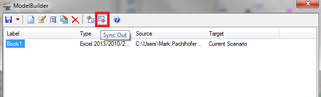
6) On the Modelbuilder manager window click the sync out button (see screen shot below) to export the GIS-IDs from your model to your spreadsheet.
Now you can take this data and create a new column in your pipes shapefile then copy and paste this data in.