| Product(s): |
StormCAD, SewerGEMS, CivilStorm |
| Version(s): |
10.00.00.40 |
| Area: |
Layout and Data Input |
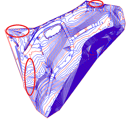
Problem
When using a LandXML file in the Terrain Model tool, the boundary lines are not respected. Contour lines are shown beyond the boundary lines. For example:
As seen in Civil 3d, as an example:
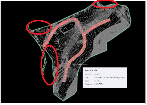
As seen as a Terrain Model layer in SewerGEMS, CivilStorm or StormCAD:
Solution
Most likely the LandXML file does not have a formal Boundary specified. Open the file in a text editor such as Wordpad. Within the section "<SourceData></SourceData>", a "</Boundary>" should be defined. If it is not, then the file is essentially just points and faces, with no formal boundary data to constrain a triangulated version of the terrain model, which the Terrain Model feature needs to process.
Software such as AutoCAD Civil3D is OK with just reading in the faces, but Bentley products (and other civil products also) have to run the points through our own triangulation routines to create a triangulated mesh for the terrain, and therefore we need more information in the SourceData section, such as boundary data, to tell the program where to exclude triangles that can be drawn at the given points.
So, the solution is to define a Boundary in your LandXML file. If you're using Civil 3D and are unsure of how to do this, please contact Autodesk.
Alternate Solutions
Method 2
1. Clean the surface from any edits in the boundaries option
2. Export to a LandXML file.
Method 3
1. Extract 3D polylines from contours of the modified surface and copy it.
2. Open new civil 3d tab file and paste the 3D Polylines.
3. Convert it to a Surface.
4. Export it to a new LandXML file.
Method 4 - for DWG contours
1. If you don’t already have it, go to https://manage.autodesk.com/cep/#products-services/updates and download and install the “Autodesk Civil Engineering Data Translator,” released Dec. 2018.
2. Run this application in Windows. Browse to the DWG file with the surface in it and choose to export as GEOPAK.
3. Wait for the online service to complete, then download the GEOPAK files. Several files will be created but the one you need is the TIN file for your surface of interest.
4. In your OpenFlows product, open the Terrain Model tool, select Bentley Terrain Model File as the Source Type, select the .TIN and proceed.
See Also
Wiki: Using Terrain Extractor (Trex)
Forum Thread: Sewergems Terrain Model - Importing Land XML from Autiocad Civil 2014