| Product(s): |
OpenFlowsTM FLOODTM |
| Version(s): |
CONNECT Edition (v 10.02.01.01) |
| Area: |
Installation |
Overview
The latest release of OpenFlows FLOOD introduces various updates to the previous version as well as addition of new features, tools and functionality to improve user experience, results interpretation, and to provide a more holistic approach towards modeling. We shall go over these updates and features in detail below.
Table of Contents
Subscription Entitlement Service
This release uses Subscription Entitlement Service Type Licensing (formerly known as CONNECT Licensing), a major advancement in Bentley's product licensing methodology. Subscription Entitlement Service Licensing gives organizations much more control over license usage and reporting, with the capability to establish concurrent use thresholds, group users with different levels of access and more. More information on Subscription Entitlement Service Licensing and how it works can be found here: Licensing OpenFlows products - Subscription Entitlement Service
Important note: With the Subscription Entitlement Service Licensing, you will need to sign in to the CONNECTION Client (included with installation of FLOOD). If you do not currently have an account that is properly linked to your organization, please contact your Site Administrator, who can add you.
Supported Operating Systems and Platforms
Compatible Operating Systems:
Windows 10 (64-bit)
Windows 8.1 (64-bit)
Windows 7 (64-bit)
Connection with SewerGEMS models
With this release it is now possible to directly link existing SewerGEMS model files (.stsw) to integrate seamlessly with MOHID Land. This enables to create a link between the 1D SewerGEMS data with the 2D surface runoff data.
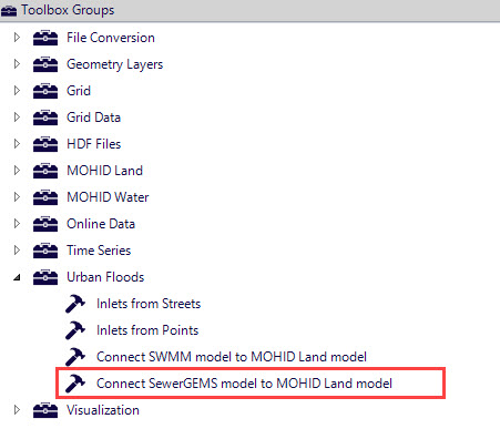
This tool can be accessed in the Toolbox Menu under Urban Floods (Toolbox > Urban Floods > Connect SewerGEMS model to MOHID Land model).
The integration is easily done by inputting the SewerGEMS model configuration file (.stsw file) and the MOHID Land (surface) digital terrain model. The tool then generates new output files (2 or 4 – in case channels exist in the SewerGEMS project) to be indexed in the FLOOD project configuration. This tool also includes additional options such as forcing the (SewerGEMS) node elevation to the (MOHID Land) DTM elevation (avoiding for instance manholes located below or above the ground).
Note: The earlier version of FLOOD only supports linking of a SewerGEMS model via a SWMM file (.inp format). However, this has been retained in this release also along with the option of directly linking a SewerGEMS model (.stsw format).
See this article for more details on this: Integrating SewerGEMS or CivilStorm with OpenFlows Flood for 2D simulations
Although the above option mentions connectivity of a SewerGEMS model with FLOOD, technically a model created in any of the four storm-sewer products viz. SewerCAD, StormCAD, CivilStorm and SewerGEMS can be used to link with FLOOD since the file type for all these products is the same (.stsw).
Map Visualization Improvements
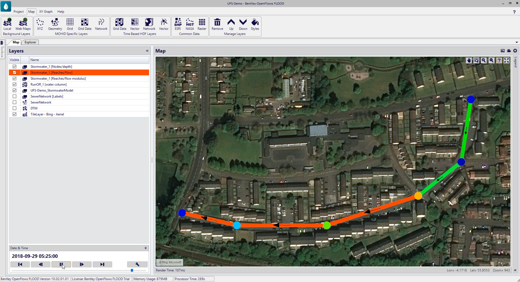
With this new release there are improvements made in the way maps are visualized in FLOOD. You can now color code nodes, pipes and channels for a better visualization experience. You can also visualize flow and velocity vectors in pipes or channels in a better way.
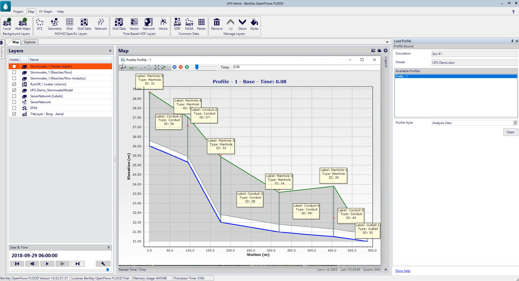
Hydraulic Profile View
If the SewerGEMS model which is linked with FLOOD using the new tool, contains profile views created prior to linking; then these will be available inside FLOOD. Using this tool, the available profiles are automatically listed, and the user can select and visualize the hydraulic profiles. Similar to SewerGEMS, the user is able to visualize both types of profiles i.e. analysis profile and engineering profile.
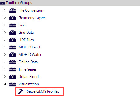
This tool can be accessed in the Toolbox Menu under Visualization (Toolbox > Visualization > SewerGEMS Profiles).
Improved Numerical Modeling
With this release there are improvements in the numerical modeling solvers computing for 1D drainage networks (pipes and channels – both natural or artificial) using SewerGEMS (SWMM) numerical solver. This will provide more realistic results whenever (and wherever) complex hydraulic structures are included in the modeling scenarios.
Also included is a new dynamic bidirectional link between 2D surface runoff using MOHID Land solver and channels (artificial and rivers) using SewerGEMS (SWMM) solver. This ensures more accurate and realistic results in cases where exchange between pipes and (natural or artificial) channels are present.
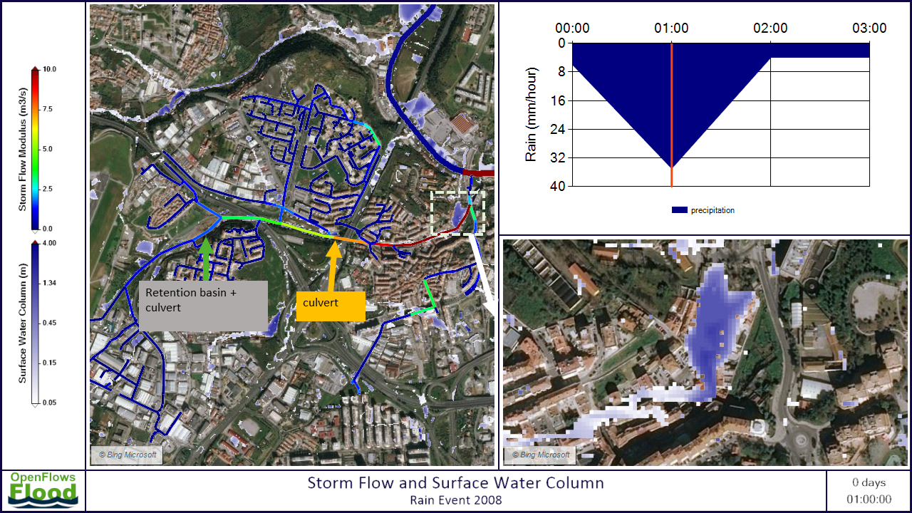
Integrated urban flood modelling (dynamic exchange between 1D open channels, 1D hydraulic structures such as culverts and retention basins) and 2D surface runoff
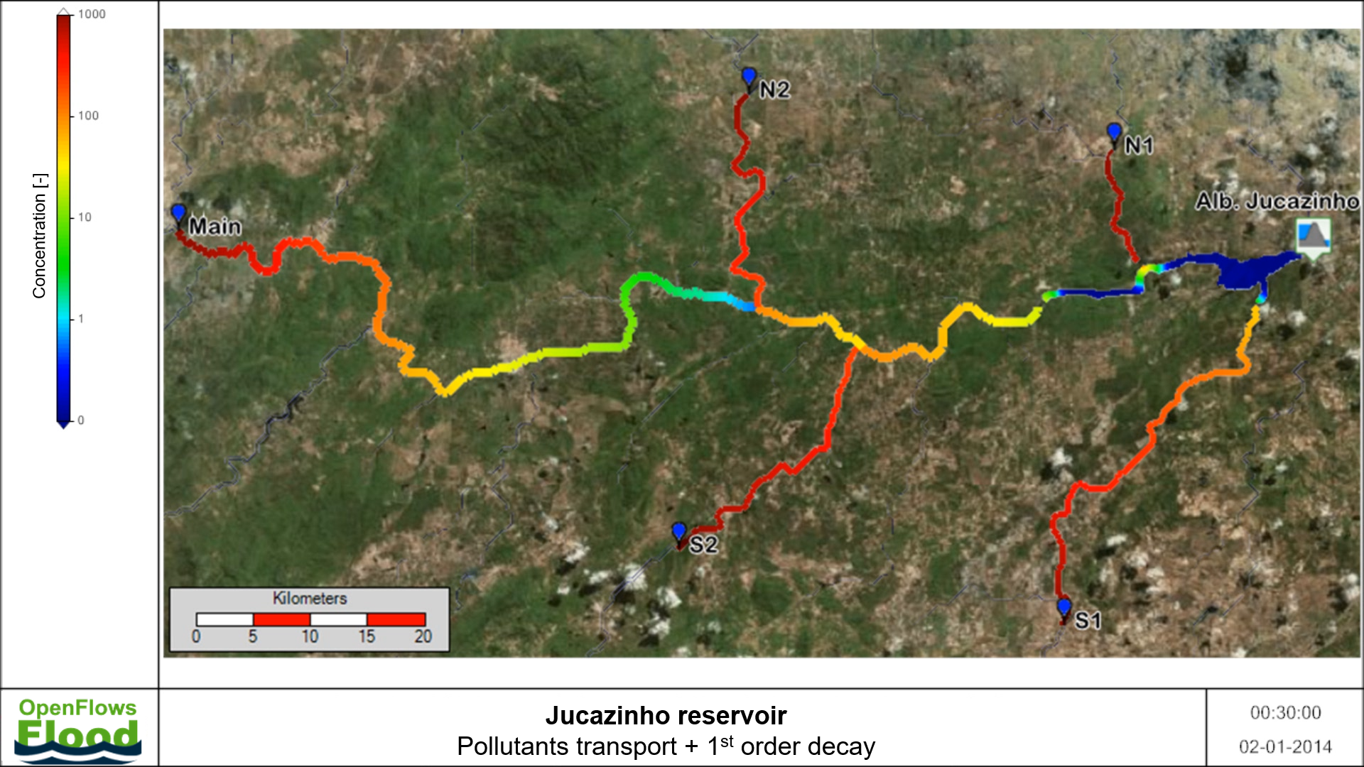
Water Quality Modeling Improvements
In addition to the existing capabilities, this release includes the MOHID water quality / water pollution comprehensive capabilities. Apart from property transport (advection-diffusion) in all mediums (coastal and inland surfaces, rivers, soil and groundwater), property transformation is also possible, either using specific and comprehensive water quality models or simple decay approaches.
This expands the range of applicable uses of FLOOD - for instance, allowing the study the water quality impact in a river or coastal area as a result of an emergency discharge (runoff) due to a storm event.
Feature Video
The below short demo includes a preview to the new features of FLOOD
Downloading OpenFlows | Hydraulics and Hydrology Software
How to receive alerts on new version availability
OpenFlows | Hydraulics and Hydrology Forum