| Product(s): |
OpenFlows FLOOD |
| Version(s): |
10.03.XX.XX |
| Area: |
Help and Documentation |
In the simulation of coastal hydrodynamics, OpenFlows FLOOD uses a global tide model solution generated by FES2014 to impose water elevations at the open boundary. FES2014 is the last version of the FES (Finite Element Solution) tide model developed in 2014. A new database was developed based on this model containing 34 tidal constituents distributed on 1/16° grids (amplitude and phase). More information can be found here.
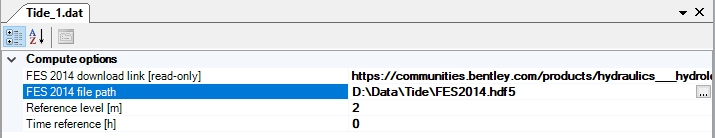
This database was rearranged into a HDF5 file ready to used by OpenFlows FLOOD which can be downloaded here (8.76 GB). Once it's downloaded in your computer, you can store it a fixed location.
To use this dataset in OpenFlows FLOOD, while setting up a coastal hydrodynamics simulation with tide imposed at the open boundary, go to the Tide module and in Compute options -> FES2014 file path, browse for the FES2014.hdf5 file and save. You can also edit the reference level and the time reference properties. Reference level is refers to a specific tide gauge, and it is typically assumed as the difference between mean sea level and the lowest observed sea level (by that tide gauge). Time reference specifies the time difference (in hours) between UTC (Coordinated Universal Time) and local time and can be used to run a simulation in local time. For example, if the time reference is zero it means the model is assuming UTC, if it's -5 it's EST (Eastern Standard Time).
Important note: to be able to use FES2014, your computational grid must be constructed in WGS84 geographical coordinates.