| Product(s): |
WaterSight |
| Version(s): |
10.00. |
| Area: |
Documentation |
Overview
Administration page to upload customer meters characteristics. This information is uploaded trough an excel file, which template is available for download in the Digital Twin Setup page, under Download Templates (Configuration file). The excel tab that must be completed is the one called "Customer Meters", shown in the figure below.
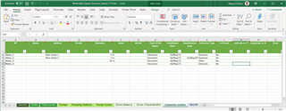
Figure 1 - Template Excel file containing the customer meter information that can be imported to WaterSight.
Meters information should come (at least customer meters ID and geolocation), whenever possible, from the commercial system, to assure that the most up to date information is imported into WaterSight. Information about billings (Customers Billing, inside the administration menu) together with meters geolocation (coordinates or zone) is used to compute the revenue of each zone, used in the water balance diagram. Customer meters fields such as Name, Address, Customer type, Is Critical are also used in the Operational events runs.
Upload and Delete
Use the delete button located on the top of the table to delete the current meters file.
Use the upload button located on the top of the table to upload a new meters file. 
After the first upload, the user can continue to update the meters file by directing upload new a new file. Please note that in case a file was already uploaded before, the upload of a new file will add the new meters to the system and update the existent ones (if a meter already existed before and it is not contained in the new file, it will be kept and not deleted). If the user wants to overwrite/replace all the old meters by the new meters contained in the new file, he first needs to delete the current meters before uploading the new file.
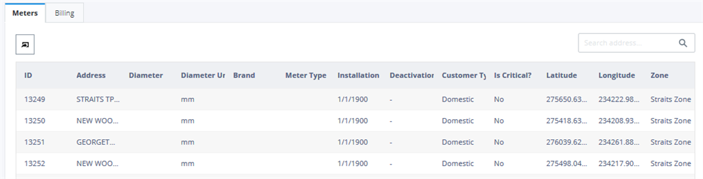
Meters Configuration table
Note: Minimum required fields are marked with an asterisk.
| Column |
Description |
| ID* |
Customer meter ID. Must be unique for each meter and must match the ID provided in the monthly billing files. This ID should also match the Billing ID field in the uploaded WaterGEMS hydraulic model, in case customer meter elements exist.
|
| Address |
The address associated with each customer meter. |
| Diameter |
Diameter of each customer meter
|
| Diameter Units |
Diameter units of the customer meters |
| Brand |
Brand/Model of the customer meter |
| Meter Type |
Type of meter (example: volumetric, velocity/turbine) |
| Installation date |
Date when the meter was installed. |
| Deactivation date |
Date when the meter was deactivated. |
| Customer type |
Type of customer. Options available are: domestic, industrial, services, other. |
| Is Critical |
Identify which customers are critical (for example an hospital) |
| Latitude |
Latitude where the customer meter is installed. The coordinate system should be defined by the user before the upload of the file in the settings. (optional) |
| Longitude |
Longitude where the customer meter is installed. The coordinate system should be defined by the user before the upload of the file in the settings. (optional)
|
| Zone |
Only required if coordinates field is not defined. Zone that each customer meter belongs to. The zone name should be the same used in the zones polygon shapefile uploaded in the administration menu, in the GIS page.
|
 ...
...
For more information about WaterSight, please go to OpenFlows WaterSight TechNotes and FAQ's.