| Product(s): |
SewerGEMS, SewerCAD, StormCAD, CivilStorm, WaterGEMS, WaterCAD, HAMMER |
| Version(s): |
CONNECT Edition, V8i |
| Area: |
Layout and Data Input |
Problem
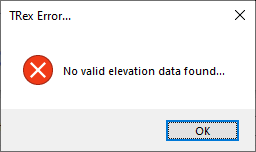
When attempting to import elevation data using Terrain Extractor (Trex), the following error occurs:
"No valid elevation data found"
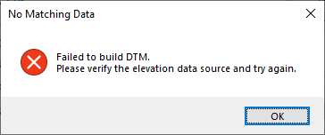
"Failed to build DTM..."
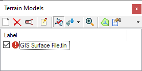
Or, when attempting to load a file using the Terrain Model feature, no elevation field is available and a red exclamation point displays next to the file in the Terrain Model manager.
Solution
This error generally indicates that Trex could not find any Elevation attribute field in your selected file. First, click the "Select Elevation Field" dropdown and ensure the correct field is chosen which stores the elevation data for your contours or points.
If no field is available in the "Select Elevation Field" dropdown, there may be a problem with the source data. Try opening the file in the source application (or another application that can read the file) and check to make sure that an elevation field is available and that there are no problems with the file.
Another cause is that the file type is not compatible. For example when selecting "Bentley DTM file" as the source type, only Bentley terrain files (generated by Bentley products like GEOPAK and Inroads) are supported. There are cases for example where TIN files can be generated by other applications such as AutoCAD, which are not in the expected Bentley DTM format and thus not compatible with Trex. In such cases, you can try opening the file in the source application (for example AutoCAD) and export the DTM into LandXML or Shapefile and then use it with Trex or the Terrain Model feature.
See Also
Troubleshooting and Understanding TRex - Terrain Extractor tool